The Trinity Alps Wilderness Area is a large protected wilderness located inside the Shasta Trinity National Forest in far northern California. It is one of the largest wilderness areas in California, and also one of the least visited.
We drove up from the Bay Area on Saturday afternoon, and spent the night in Weaverville at the Red Hill Cabins. Sunday morning we arose early, picked up sandwiches and coffee at the local Tops market, and headed up California 3 toward the Trinity Alps. At Trinity Center, where Swift Creek enters Trinity Lake (formerly Clair Engle Lake, which is a story all to itself), we left the paved road and drove 8 miles on Forest Service dirt roads up to the Poison Canyon trailhead. Trinity Center is at about 2,500 feet elevation, while the trailhead is at 4,100 feet elevation; the Forest Service road took almost 45 minutes to drive.
When we got to the trailhead, we were a trifle concerned when we noticed that the brand new Toyota 4Runner parked there had been apparently attacked by a bear: there were paw marks on the windows; two fiberglass side panels were torn off the car and lying on the road; and when we looked into the car window, a cooler was sitting open on the back seat. We had no food to leave in the truck, so we carefully moved our overnight bags of spare clothes into the center-front of the truck bed, covered them with a grey blanket, closed the truck up tight, and hoped for the best.
 |
| From BryanTrinityAlps2010 |
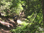
The Poison Canyon trail leads upward along the North Fork of Swift Creek, staying close enough to the creek to hear the water, but not close enough to see the creek. The trail is steep: it climbs 1,800 feet in just 2 miles, which is about a 17% average grade. Happily the trail leads mostly through shaded woods and pleasant meadows, so even though it is steep and unrelenting, we took our time and enjoyed the walk. Poison Canyon is apparently named due to a type of grass which grows there, which is indigestible by the livestock. Of course, we backpackers refrained from chewing the plants...
As the trail rises through the canyon, we start to see views of towering Ycatapom Peak, the 7,600 primary landmark of the area.
 |
| From BryanTrinityAlps2010 |
After a long break for lunch, we arrived at Lilypad Lake in mid-afternoon, and spent a few hours selecting the best campsite and setting up camp. As the guide books had predicted, we had the canyon to ourselves, and so we picked a great campsite high on the boulders above the lake, near the feeder stream with its pleasant running water. Firewood is abundant in this area of the Alps, and we had an enjoyable campfire before an early night, as we were all quite tired.
 |
| From BryanTrinityAlps2010 |
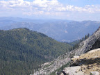
Monday morning we headed up the Thumb Rock trail above Lilypad Lake. Again, this trail is very steep, but since we were only carrying light day packs it was much more tolerable, and we made good progress. The trail takes you quickly up 600 feet above the lake, where the views of Mount Shasta are tremendous! We climbed a bit further, past the junction with the Deer Flat trail, to a knoll above Poison Canyon with a spectacular view, at about 7,000 feet of altitude. After lunch, we hiked a bit further, to the crest of the Parker Divide, where we got a 360-degree view of the eastern Trinity Alps, including the Parker Creek canyon, Cub Wallow, and Deer Flat. We split up, with Roger and Rich heading off to climb Thumb Rock's neighbor peak (elev. 7735), while Mike, Deb, and I returned back down the switchbacks to Lilypad Lake for some rest, book reading, and wildlife study.
 |
| From BryanTrinityAlps2010 |
The shooting stars were great on Monday night! I think we were 3 days early for the Perseids, but we still saw lots of meteors.
Tuesday morning dawned cold and grey, with heavy clouds overhead. Tired and a bit discouraged, we cancelled our plans to take the 8 mile (round trip) hike over to Boulder Lake, and instead decided to play campground games: horseshoe golf, poker, and rock skipping were all favorites. Unfortunately Rich didn't get to use his fishing pole; maybe next year!
Wednesday we broke camp and headed back down to the trailhead. Happily, Mr. Bear had decided that there was nothing worth fighting for in the truck, and we sailed back down the dirt road, through Weaverville, back to I-5, and (eventually) made it home to the Bay Area for the conclusion of another great trip.
For more pictures, see my online web album!
No comments:
Post a Comment